


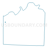
KC WD4 PCT409, Jackson County, Missouri
About
Outline

Summary
| Unique Area Identifier | 608463 |
| Name | KC WD4 PCT409 |
| County | Jackson County |
| State | Missouri |
| Area (square miles) | 0.13 |
| Land Area (square miles) | 0.13 |
| Water Area (square miles) | 0.00 |
| % of Land Area | 100.00 |
| % of Water Area | 0.00 |
| Latitude of the Internal Point | 39.05390040 |
| Longtitude of the Internal Point | -94.58277190 |
Maps


Graphs
Select a template below for downloading or customizing gragh for KC WD4 PCT409, Jackson County, Missouri


Neighbors
Neighoring Voting District (by Name) Neighboring Voting District on the Map
- KC WD4 PCT405, Jackson County, MO
- KC WD4 PCT406, Jackson County, MO
- KC WD4 PCT407, Jackson County, MO
- KC WD4 PCT408, Jackson County, MO
- KC WD5 PCT410, Jackson County, MO
- KC WD5 PCT502, Jackson County, MO
- KC WD5 PCT509, Jackson County, MO
Top 10 Neighboring County Subdivision (by Population) Neighboring County Subdivision on the Map
Top 10 Neighboring Place (by Population) Neighboring Place on the Map
Top 10 Neighboring Unified School District (by Population) Neighboring Unified School District on the Map
Top 10 Neighboring State Legislative District Lower Chamber (by Population) Neighboring State Legislative District Lower Chamber on the Map
Top 10 Neighboring State Legislative District Upper Chamber (by Population) Neighboring State Legislative District Upper Chamber on the Map
Top 10 Neighboring 111th Congressional District (by Population) Neighboring 111th Congressional District on the Map
Top 10 Neighboring Census Tract (by Population) Neighboring Census Tract on the Map
- Census Tract 168, Jackson County, MO (3,556)
- Census Tract 167, Jackson County, MO (3,368)
- Census Tract 67, Jackson County, MO (1,795)
- Census Tract 51, Jackson County, MO (1,651)
- Census Tract 65, Jackson County, MO (1,640)